
Yuma is one of those iconic towns of the west, like Tombstone. If Tombstone has its OK Corral, Yuma has its 3:10. Situated along the once mighty Colorado River, baking in the Sonoran desert, it is at the southwest tip of Arizona, just a few feet from the California border. According to Guinness, the area surrounding the city is the sunniest on earth, although NASA scientists say that this distinction is held by a Sahara Desert site in northern Niger. The sun shines in Yuma for 4,050 hours of the 4,456 hours of daylight during a year, or about 90 percent of the time. All that sun and the desert terrain make it hot, with an average daily high in July of 107 degrees Fahrenheit. On July 28, 1995, the temperature reached 124 degrees!
We drove into Yuma on Interstate 8, which begins as a split with Interstate 10 north of Tucson. It’s all desert, all the time, although there are many lovely mountains, and the day we went, we saw brilliant bouquets of wildflowers, alongside the road and in the distance. The best scenery is on that part of the road that goes through the Sonoran Desert National Monument. It is always surprising to me to see how many mountains there are in desert regions, or that while you are driving, you begin to climb and might actually go through a pass. We noticed that the saguaro cactuses out our windows looked beaten down, almost all of them charred and scarred at their bases. Perhaps these sentinels of the desert had lost the battle to survive the modern human assault on their habitat.
We passed the town of Gila Bend, about sixty miles from the Interstate 8/10 split, named for a sharp bend in the Gila River, which empties into the Colorado near Yuma. When I was a boy, I checked the newspaper every day for the lowest and highest temperatures in the United States. Gila Bend was a frequent winner for the high, as was its neighbor Yuma.
Yuma is in a wide river valley, and the original inhabitants fished, hunted, and planted crops. Before it was defiled by so many dams, the Colorado was a rushing river, prone to massive flooding. This made crossing it a dangerous venture. Here, however, there are two large rocky mounds, one on each side of the river. “Indian Hill and Prison Hill narrowed and calmed the river just a few miles south of the confluence of the Gila, at the present location of Yuma, Arizona. ” The Prison Hill in the quote is where the famous territorial prison was located. Parts of it are still there, and what is left is part of the Yuma Territorial Prison State Historical Park. When the prison closed in 1909, it fittingly became Yuma Union High School, perhaps like my high school, a prison for the mind. Indian Hill is on the California side of the Colorado, on part of the Quechan Indian reservation. The Quechen and the Cocopah Indians occupied the Yuma region when the Spaniards came calling. They were farmers and hunters, taking advantage of the river and the natural crossing. Spain and then the United States saw the usefulness of the crossing too, though they had different objectives in mind: military expansion, commerce, a place to build a bridge for settlers, prospectors, and the like. Though the Indians were friendly, they soon came into conflict with the Europeans, a conflict they eventually lost, along with their lands. We walked across the one-lane bridge, which is flanked by a railroad span, along which there is a steady flow of train traffic, and looked at the old mission church and the Quechan tribal buildings. A few hundred feet down the road, we saw a casino. Inside, there was the usual depressing sight of people losing money who cannot afford to do so, smoking and looking generally unhealthy. Indian casinos are often not owned directly by the tribe, and few native people benefit from them. Here is what my friend Jim Craven—Blackfoot Indian, scholar, and activist—said to me about them:
From every gross profit casino dollar (keep in mind that non-Indians control the accounting as well as supplies of inputs—vertical integration—at inflated prices thus making paper profits appear smaller than they actually are) subtract 51 cents for “investors” (Bally, Harrahs, etc., all non-Indian), leaving 49 cents. Then subtract 31 cents (consultants, licensing, taxes, lawyers etc., all non-Indian), leaving 18 cents. Then subtract 5 cents (BIA/DIA “holding, transactions and other fees”), leaving 13 cents. Then subtract 5 cents (skimming by BIA/DIA or “Vichy” Indians on the Tribal Councils), leaving around 8 cents of every gross profit dollar for per capita distributions and tribal programs,” often themselves dominated by the traitors and their families. (From Chapter Six of my book, Cheap Motels and a Hot Plate)
The population of Yuma is about 90,000, up more than 16 percent since 2000. Unlike many similar cities, Yuma still has a downtown. There are covered sidewalks with ceiling fans, a stately post office building (unfortunately sold to a private company), a movie theater, shops, and restaurants. Not many people were downtown the days we walked around, and this lack of foot traffic will be a problem for any revitalization. There are some museums and numerous law offices, the latter because there is a large court and criminal justice complex in this area. A few of the small houses are lovely, with large trees and desert plants in the yards. The city has made efforts to beautify the river shores, and there are two wetland areas that include parks and a playground. There is also the Yuma Quartermaster Depot, a park with some of the buildings used by the old Fort Yuma to supply the other military outposts in the region. As you radiate outward from the downtown, the housing gets a bit more shabby and poor. Further out, there are scores of RV parks (a google search yielded 389)—homes to winter residents—with names like West Wind, Mesa Verde, Suni Sands, Shangri-La, Friendly Acres, Desert Paradise, Sun Vista, and Twin Palms. Some have pools and small golf courses, but most are depressingly ugly and uniform. We saw one along the river, right in the shadow of the freeway, trucks rolling by day and night. The older people who live in these RV parks have helped to spur Yuma’s population growth, and no doubt their money is appreciated by the locals.. But the thought of living in an RV park fills us with dread. Karen always says, what would it be like to have a full day of hiking and arrive home to a trailer. People come to the desert to die. I may die in the desert, but it won’t be because I am here to live among the retirees, playing shuffleboard and bingo and waiting for the early bird specials. Perhaps cold weather becomes such a burden for the elderly that they will do anything to escape it. A couple of hours north of Yuma is Quartzite, where hundreds of trailers squat in the desert, on the hard stony soil. There, every winter, old desert rats set up a swap meet, organize entertainment, and hunt for gemstones. A more gruesome looking place it is difficult to imagine, unless it is “Slab City” by the Salton Sea, a glimpse of which you can get in the Sean Penn film, “Into the Wild.” It’s not too far from Yuma either!
Where there are deserts, there is the military, and Yuma is no exception. There is a Marine Corps Air Station and the Yuma Proving Ground, which take up enormous desert spaces. Here is what the wikipedia entry says about the Yuma Proving Ground:
The U.S. Army’s Yuma Proving Ground is one of the largest military installations in the world. Situated in southwestern La Paz County and western Yuma County in southwestern Arizona, U.S., approximately 30 miles (48 km) north-east of the city of Yuma, the proving ground is used for testing military equipment and encompasses 1,307.8 square miles (3,387.2 km) in the northwestern Sonoran Desert. The proving ground conducts tests on nearly every weapon system in the ground combat arsenal Munitions and artillery systems are tested here in an area almost completely removed from urban encroachment and noise concerns. Restricted airspace controlled by the test center amounts to over 2,000 square miles (5,000 km2). Nearly 3,000 people, mostly civilian, work at the proving ground. It is a major economic player in Yuma County, with an economic impact of over $430 million annually. Yuma Proving Ground is the largest single employer of civilians in the county.
In a typical year, over 500,000 artillery, mortar, and missile rounds are fired, 36,000 parachute drops take place, 200,000 miles (320,000 km) are driven on military vehicles, and over 4,000 air sorties are flown from the proving grounds Laguna Army Airfield. Though about 90 percent of the proving ground’s workload is devoted to the test and evaluation of weapon systems and munitions, training activities are important. Dozens of units visit the proving ground each year for realistic desert training, especially before deploying overseas
Thus does our government train killers, develop new weapons of mass destruction, and destroy the fragile desert environment—all in the name of peace.
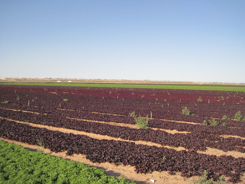
Another “major economic player” is agriculture. We began a drive on West 1st Street, along the northern perimeter of Yuma, and before you knew it, the city gave way to what the great editor of The Nation Carey McWilliams called “factories in the fields.” Farming is big business in Yuma, but there is nothing farm-like about it. Agriculture is highly mechanized and rationalized, so that McWilliams’ description is more accurate now than when he wrote about the mass-production supplying of our food. According to the Lower Colorado Region Salinity Assessment Network :
Yuma County supports more than 180,000 acres of irrigated agricultural land. Multiple crops are grow throughout the region, including lettuce, cotton, carrots, broccoli, and melons, in addition to citrus groves, fruit and nut orchards, and grapes. The Yuma Agricultural Center (YAC) is operated by the University of Arizona, and carries out both research and cooperative extension projects in support of the Yuma agricultural community. Active research areas at the YAC include programs in crop science, entomology, animal science, plant pathology, and soil and water science.
The irrigated land is publicly subsidized, and the water comes from the Colorado River. The University of Arizona, like the University of California at Davis, does publicly funded research that mainly benefits the growers. Food is relatively cheap in the United States, but the social costs are high. Dammed rivers ruin the land up- and down-river. Heavy dosages of pesticides fool the soil, air, and water. So heavy were the chemicals in use on the fields we drove through as we turned south on our drive that our throats tightened, and it was difficult to speak. The labor force is immigrant, poorly paid, and badly treated, with life expectancies of about fifty, the same as they were fifty years ago when Edward R. Murrow produced Harvest of Shame. We eventually drove east back toward Yuma, and we passed through the farm worker town of Somerton. Twelve thousand people live here, 95 percent Hispanic, with a per capita income of $9,600. In Somerton, agriculture is the most important industry and occupation. The economic crisis has devastated farm workers. The unemploymnet rate in Somerton is more than 17 percent, and over a quarter of the people are living below the already meager povertylevel of income.
We saw worn buses picking up farm workers in the fields and in a shopping center parking lot. The next day, we left Yuma and traveled north toward Las Vegas. Again, we drove through enormous fields, mainly lettuce, probably Yuma’s biggest cash crop. We took some pictures,
and I thought about Cesar Chavez, who was born in Yuma. I have had many harsh things to say about him and the United Farm Workers union he helped build and then destroy. At the end of a story I wrote about the time I worked for the union, I wrote:
The Grapes of Wrath was published in 1939. A lot has changed since then; a lot of working people began to make a fairly good living, even buy good cars and houses and send their kids to school. But for farm workers the changes haven’t been so great. They’re still dirt poor. They’re still sickly, from lousy food, from pesticides, from fouled water. They still don’t often live past 50. And their kids still don’t go to school. Their skin colors change, but their lives don’t. And what’s true here is true everywhere in the world where the big growers own the land. Money is what they want, money in a ceaseless and growing flow, and the way to get it is to have a large reserve army of people without land whose only choice is to harvest the crops for nothing or die. The big growers will do whatever they have to do, including kill people outright, to insure the existence of the landless masses. And this is true in the United States, in Mexico, in El Salvador, in the Philippines, in Indonesia, everywhere the land and its bounty have become merely things, to buy and sell. (From my book, In and Out of the Working Class)