We left Capitol Reef, wishing we could stay longer. The last leg of our trip would take us to one of our favorite haunts—Moab. The drive time is about four hours, but the nice thing about Utah is that the traveling is almost as enjoyable as the destination. There is seldom a boring mile. Most of the trip is along Utah 24, another “scenic byway,” not completely paved until the 1960s. After the Mormons colonized the southeastern part of Utah, in the years following the expedition through the Hole in the Rock, they began to backtrack westward and establish settlements. Some of the land surrounding the Fremont River was suitable for farming and ranching, and communities were formed in Hanksville, Caineville, Torrey, and Fruita. The last one was the most interesting. Founded around 1880 and originally named Junction because it was at the confluence of the river and Sulphur Creek, Fruita (pronounced “froot-uh”) became famous for its fruit trees. The village itself never housed more than a few families, but the orchards helped them to prosper. Utah.com tells us:
Though it never comprised more than 300 acres Fruita — originally called Junction — became an important settlement due to its relatively long growing season and abundant water. Settlers from nearby Torrey and Loa — which each have 90-day growing seasons — arrived in Fruita and planted thousands of trees bearing Jonathan, Rome Beauty, Ben Davis, Red Astrachan, Twenty-Ounce Pippin and Yellow Transparent apples, Morpark apricots, Elberta peaches, Bartlett pears, Fellenburg plums, and the Potawatomi plum. Settlers also planted English and black walnuts and almonds. Grape arbors appeared later.
The author might have added, but Anglos rarely do, that the Mormons in Fruita took advantage of irrigation paths first constructed by the true first settlers, the indigenous Americans.
Most production in Fruita was either consumed domestically or bartered; if money was needed, the fruit could be sold in larger towns such as Richfield. The son of a school teachers at the one-room school that still sits beneath the cliffs that line the river remembers his parents owning a 1924 Chevy. His father was principal at the “big” school in Torrey and drove the car down the dirt road to be with his family in Fruita every weekend. Cash might have been needed for this automobile, though goods could have been traded for it. In either case, the economy of Fruita was what Marx called simple commodity production; at most money was a medium of exchange and the accumulation of capital was not in evidence. It also appears that Fruita was not a diehard Mormon community. There was never an LDS church, and residents don’t seem to have minded an occasional drink or a visit from local outlaws.
Fruita continued its simple existence until the federal government made the area around it a national monument (and eventually Capitol Reef National Park) and began to buy up the properties. Sadly, most of the buildings were torn down. A few still stand, however, around the park’s visitors’ center and along the river. We like to stop at the schoolhouse, which closed in 1940, and look inside the windows. We imagine what it must have been like to learn to read and write in one small room or to attend Fruita’s social events and meetings, which were also held at the school. 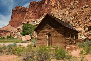 Remarkably, some of the fruit orchards are still intact and cared for by the Park Service; visitors can pay a small fee and pick the ripe cherries, apricots, pears, apples, and peaches.
There is not much traffic and not many people living between Capitol Reef and Moab. Caineville is pretty much a ghost town, and Hanksville has a population of 360. The land beyond the river and washes is largely treeless and desolate, though there is a stark beauty in the black coal-like hills and mesas and worn out desert wastelands. Every now and then, you see a trailer or shack in the distance, and you wonder what in a person’s life would lead him or her to live there. Along the sides of the road, you also see decaying homesteads, cafes, motels, and campgrounds. You can see the same in Hanksville as well.
Utah 24 veers north at an intersection in Hanksville, toward Interstate 70. This is the quickest way to get to Moab. However, the road south, Utah 95, passes through or close to some interesting places: the Henry Mountains, the bridge over the Colorado at Hite, Natural Bridges National Monument, and the Four Corners area, with numerous attractions. The road ends at U.S. Highway 191 near Blanding (we witnessed German tourists in Blanding who could not fathom the idea of nonalcoholic beer!), and from there you can drive north seventy-six miles to Moab.
We took the shorter route, not just to save time but because we wanted to visit Horseshoe Canyon to see the famous rock art panels there. The canyon is at the end of a thirty-mile barely marked dirt road; from there you have to take a six and a half mile (round trip) hike to see the art. We were excited to see one of the most amazing galleries of rock art in the world, but it was not to be. The road was badly wash-boarded, and our poor old Dodge Caravan wasn’t up to the task. Before the car rattled apart, we gave up and turned around. Back on 24, we looked out on the other side of the road, toward Goblin Valley State Park, where last year on November 16, a Colorado woman, Rose Backhaus, went hiking alone and never came back. She left her Moab motel room to go hiking in the park. Her car was found eight days later; in it there were extensive notes of her trip and where she had hiked. She said on the sixteenth that she was “happy,” that it was “warm, nice, and something new.” Her body was found five months later in a narrow slot canyon. She may have gotten lost and died of exposure. We were in Moab last year too, and we were saddened by her disappearance. Exposure to cold may not be the worst way to die, but until delirium sets in, you must know what is going to happen. We could almost feel her fear. May her family know that we think of her whenever we are in the canyon country.
We got to Moab in the early afternoon and checked into our old faithful Big Horn Lodge. We get a low weekly rate in November, the only catch being that we only get the bed sheets changed and the room fully cleaned once a week. This works well for us, and since I plugged the place in my book, Cheap Motels and a Hot Plate: an Economist’s Travelogue, everyone is solicitous and friendly.
Moab is a tourist town and a national destination for jeep, bike, river, and hiking enthusiasts. It is also a gritty place, not particularly prosperous for the locals, a fair number of whom appear to lead a kind of rough and ready life. Houses and yards are often unkempt and shabby, with more than the usual amount of rusty cars, trucks, buses, and sundry junk in every nook and cranny of outdoor space. The general appearance of the place belies the stunning natural beauty all around.
I’ll have more to say about Moab in my last Utah post. We spent two glorious weeks hiking: Delicate Arch, Devil’s Garden, Hidden Valley, Corona Arch, Courthouse Wash, Negro Bill Canyon, Mill Creek Canyon, Island in the Sky, and the Needles. The last hike is in Canyonlands National Park. This vast expanse of rocks is divided into Island in the Sky, the Needles, and the Maze. The Maze is not accessible except by high-clearance, four-wheel drive vehicle, but parts of the other two can be reached by an ordinary car. The drive to the Needles takes nearly two hours from Moab, but it is worth it. Once you get past the miles-long expanse of tire shops, auto repair garages, metal businesses of one kind or another, junkyards, truck depots, horrid housing developments, and the like south of town, U.S. 191 wows you like most Utah highways. There is even a great arch, Wilson Arch, right along the road. The road into Canyonland (Utah Highway 211) takes you through open range, where you can expect to see cattle on the road and where you had better be careful not to hit a deer. In the afternoon, rock climbers will be scaling the cliffs. About twelve miles from the start of Utah Highway 211 and after a steep descent into Indian Canyon, there is a very large wall of petroglyphs known as the Newspaper Rock. This is a 200 square feet block of Wingate sandstone on which have been carved hundreds of figures, some dating back two thousand years.
There are scores of dirt and gravel roads that branch off from Utah 211, but we drove on the paved road to the Needles Visitors’ Center. We got a map and drove to the trail head for the hike to Chesler Park. There are plenty of interesting things to see in the Needles, though serious hiking and rough road driving are necessary to see some of the best parts. One easy site to visit is Cave Springs, a short loop hike over sand and rock. Under a large rock overhang, there is an old cowboy campsite. This area was once part of a gigantic cattle ranch, and this is where the wranglers bunked. We were surprised to discover that cowboys lived in this protected but still dark and damp cave until 1975. The detritus of daily life—bed springs, cans, mugs, a rough table—are still there, reminders of a bygone way of life. A short distance away, under another rock overhang, there are pictographs, a nice juxtaposition, for the ancients lived here too.
The hike we took begins at the infamous Elephant Hill jeep road, reached after a few miles of dirt road, fine for any car but with two blind curves. Elephant Hill is a technical drive, with some spots so steep that the driver cannot see what is in front and a second person must stand outside and guide the driver over the top and down the steep grade. We met a couple on a hike in Moab who tried to navigate Elephant Hill but turned back almost immediately. However, we also met a park ranger at the trail head who told us it wasn’t so difficult!
The Chesler Park hike isn’t difficult and is about six miles round trip, although you can make an eleven-mile loop hike out of it. We hiked up and over slick rocks, into a narrow and sandy canyon, and through cliffs and spires. We could see the Island in the Sky section of Canyonlands in the distance; it is fifteen miles away as the crow flies but 137 miles by car, giving you some idea of the ruggedness of the terrain. One of our favorite things to do on this hike is observe and contemplate the fantastical shapes of the rocks. There are rocks that look like spires, needles, chimneys, volcanoes, mushrooms, hershey’s kisses, hamburgers, even a wooden shoe with an arch as the instep. All in gorgeously subtle colors and striations. Every designer should be forced to spend some time in the southwest and utilize its color palette. There would be far fewer ugly interior and exterior wall paint treatments.
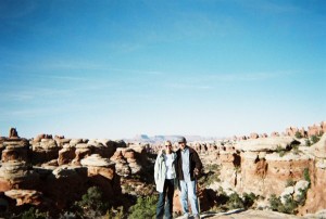
With about a half mile to go to reach the park, the trail begins to climb into the cliffs. From a distance, mountains and complex rock formations always look impenetrable. Usually, however, there is a way through them, often one first made by the native peoples. Just before the final climb through the boulders, the trail was in shade and lined with snow. The snow was finely granuled, looking like tiny anemones, or miniature stars to guide us upward and into the sun. We made it to the top of the trail and sat on some large rocks overlooking the park—a flatter, open space covered with desert grasses, wildly incongruous with what surrounds it. Somewhere in the distance the Colorado River had merged with the Green and was flowing steadily toward the roiling rapids of Cataract Canyon. We soon enough noticed the changing shadows that mark the beginning of the end of day. It was time to head back, perhaps that night to dream of timeless canyons and endless rivers flowing through them.


Frankly, the Holy Ghost panel in Horseshoe Canyon is amongst the most special things I’ve ever seen. Hard to get there without a high clearance vehicle though…
Last time I was in Moab, I almost bought Ed Abbey’s old house. It was for sale…
http://threehundredsixtyfivewalks.blogspot.com/2009/08/walk-218-ed-abbeys-house-and-delicate.html
Allan,
Thanks for this. Your comment makes us feel even worse that we didn’t have a better car! Oh well, we’ll get one soon enough and go back.
An old car of Abbey’s is for sale at Back of Beyond Bookstore.
Michael